
REVIS definition
Real-time Emission VISualisation for Eco-friendly Travel Behaviours
REVIS aim
To provide a smart system which will measure and display NO2, CO2 and particulate pollutant emissions within the built environment in real-time and be able to predict future pollutant levels for Air Quality (AQ) management.
Data will be made available to end users in a cost effective and easy to understand and use manner, becoming an enabler to reduce pollutants and improve AQ.
REVIS program
A two year IUK sponsored project to generate a real-time display and prediction equipment for NO2 (plus others) pollutant emissions within the built environment.
The Project is designed and implemented by Tier 1, Academic and Commercial companies within the UK:
- Costain Ltd: Trial site provision
- University of West of England: AI big data systems and Display
- Brunel University London: Visualisation
- Enable My Team: Data analysis and AI
- TerOpta: Sensor system Inc. IoT data to cloud
REVIS timeline
October 2018
Stakeholder engagement and market analysis
April 2019
REVIS sensor unit design completed
October 2019
A model final schematic design complete
January 2020
Video AI base unit design complete
February 2020
Traffic Monitoring Units available and Model Sensor units for initial testing
June 2020
REVIS Travel Planner (RTP) final version completed
August 2020
Prototype sensor units available
October 2020
Field Trial Sensor Units available and REVIS Cities Emissions Map and Monitor (RCEMM) completed
November 2020
Site trials start in London, Monmouthshire and Newport
January 2021
Traffic Analyser (image recognition unit) complete
January 2021
RTP and RCEMM system, integration and UAT tests
February 2021
RTP and RCEMM client demonstration and feedback gathering
April 2021
Product to market
REVIS architecture
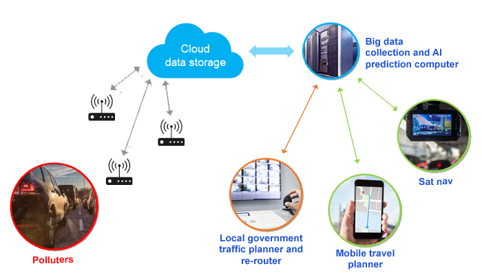
REVIS travel planner
- REVIS Travel Planner (RTP) is just one form of data display
- Intelligent traffic barring / rerouting and control
- Emission Visualisation real-time NO2 & CO2 emissions on roads
- Available to the public
- Providing drivers, commuters, cyclists and pedestrians with accurate emissions
- Enabling city planners to control and significantly improve their city environment
