REVIS aims to provide a step-change in decision-making and behavioural change for emissions reduction, and will enable local authorities to devise and test emission reduction policies tailored to their communities.
Nearly 40 million people in the UK are living in areas where illegal levels of air pollution from diesel vehicles risk damaging their health (ClientEarth 2017). According to the Royal College of Physicians (RCP), there are 40,000 deaths every year due to NO2, which has been linked to cancer, asthma, stroke, heart disease, diabetes, obesity, and dementia; resulting in high cost to people who suffer from these illnesses and costing the economy £20 billion yearly (RCP 2017). The population is worried about the issue as, in 2017, 4000 people has used air-pollution monitoring kits in the UK (Friends-of-Earth).
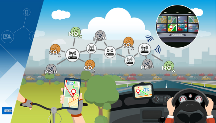
Despite the health threats accruable from emissions, no tool exists that visualises NO2 & CO2 emissions in real-time. Existing travel navigation assistants (e.g. Google Maps, Apple iOS Maps, Waze, automakers navigation systems, Tomtom, AA route-planner, etc.) do not provide information about NO2 & CO2 levels. This project will develop a system for Real-Time Emissions Visualisation (REVIS) for eco-friendly travel behaviour. REVIS will use IoT-sensors to obtain the actual amount of NO2 & CO2 emissions on roads and highways and visualise them in real-time.
May 2021 User interface demonstration video for REVIS
A video demonstration on how to interact with REVIS
May 2021 REVIS product overview video launch
A video overview of the REVIS product
September 2020 Help us deliver a more sustainable REVIS offer
As part of our sustainability agenda, we are investigating how to deliver a more sustainable REVIS offer for maximising the benefits for environment and society.
June 2019 Deployment of early Proof of Concept REVIS sensor unit
An early Proof of Concept REVIS sensor unit has been deployed at UWE premises...
REVIS is a two year £1.6 million collaborative R&D project, sponsored by Innovate UK. Project partners include TerOpta, Costain Group PLC, University of the West of England (Bristol), Enable My Team and Brunel University London.

TerOpta

Costain Group PLC

University of the West of England

Enable My Team